
Welcome to our Map collection!
Map To Illustrate Col. A. S. Waugh’s Paper on Mt. Everest & Deodanga (“Devadhunga”)- 1858
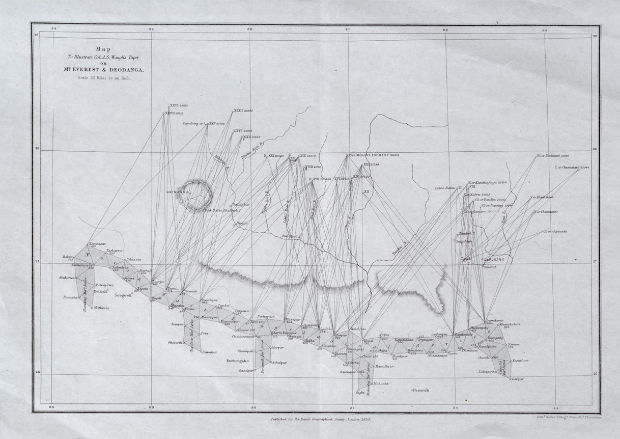
Title: Map To Illustrate Col. A. S. Waugh’s Paper on Mt. Everest & Deodanga
Publisher / Developer: Major-General Sir Andrew Scott Waugh / Published for the Royal Geographical Society by John Murray, London
Publication Date: 1858 (published in the Proceedings of the Royal Geographical Society or Journal of the RGS, Vol. 28, 1858; commonly cataloged in 1860s historical map sets)
Engraver / Lithographer: Edward Weller (Lithographer, Duke Street, Bloomsbury)
Scale: Scale 32 Miles to an Inch
Classification: Historical Geodetic Triangulation Map (Public Domain)
Context: This map was produced to accompany Andrew Scott Waugh's foundational scientific paper delivered to the Royal Geographical Society, in which he presented the official trigonometric measurements identifying "Peak XV" (named Mount Everest) as the world's highest peak and addressed local nomenclature claims (such as Brian Hodgson's proposal of "Deodanga" or "Devadhunga").
Description: Drawn on a coordinate grid spanning 84° to 89° E longitude, the map illustrates the geodetic triangulation network established by the Great Trigonometrical Survey of India. Sightlines radiate from survey stations in northern India across the Nepalese border to major Himalayan peaks—including Mount Everest (29,002 ft), Kanchinjinga, and peaks around Katmandu and Darjeeling.
Story Behind Deodanga (Devadhunga), Mt. Everest, Sagarmatha
The story behind "Deodanga" (or "Devadhunga") stems from one of the most famous geographical controversies in Himalayan exploration: the 19th-century debate over the official name and identification of the world’s highest peak.
The Origins of "Devadhunga"
In regional Himalayan nomenclature, Devadhunga (from Sanskrit/Nepali Deva = God/Divine, Dhunga = Stone/Rock) translates to "The Abode of Gods" or "Sacred Stone."
The Naming Controversy: Hodgson vs. Waugh
1847–1856 (Peak XV): The Great Trigonometrical Survey of India, directed by Major-General Sir Andrew Scott Waugh, spent years measuring high Himalayan peaks from distant observation stations in the Gangetic plains. The highest peak was initially given the neutral survey label Peak XV.
1856 (Waugh’s Proposal): Once calculations confirmed Peak XV as the world's highest mountain at 29,002 feet, Waugh proposed naming it "Mount Everest" after his predecessor, Sir George Everest. Waugh argued that no single, universally accepted local name could be verified, as both Nepal and Tibet remained closed to foreign cartographers.
1857 (Hodgson’s Challenge): Brian Houghton Hodgson, former British Resident in Kathmandu and an authority on Himalayan geography and ethnography, strongly contested Waugh's decision. Hodgson asserted that indigenous populations already had established names for the peak. He argued that the mountain was known locally in Nepal as "Devadhunga" (or "Deodanga") and in Tibet as "Chomolungma."
The Royal Geographical Society Debate: Hodgson published papers urging the Royal Geographical Society (RGS) in London to adopt "Devadhunga," adhering to standard British cartographic policy of prioritizing native names over European surnames.
Resolution and Modern Names
Waugh’s Counter-Argument: Waugh presented triangulation logs showing that "Devadhunga" likely referred to a different, lower mountain group closer to the central Nepal border (or was used by guides as a general term for sacred snow peaks in the distance), rather than Peak XV itself.
Official Adoption: In 1865, the Royal Geographical Society officially approved Waugh's recommendation, naming Peak XV Mount Everest.
Recognition of Indigenous Names: Decades later, the Tibetan name Chomolungma ("Goddess Mother of the World") and the Nepali name Sagarmatha (coined in 1956 by Nepalese historian Baburam Acharya, meaning "Head of the Sky" or "Peak of Heaven" from Sagar = Sky/Heaven and Matha = Head) gained official recognition. Today, Devadhunga/Deodanga stands as a fascinating historical chapter in early Himalayan cartography.